The Google Maps for Android app is now on a roll in 12 countries with comprehensive navigation for those wanting to avoid traffic caused by other vehicles. This application targets specifically biking and cycling routes, providing host of optional paths between two destinations.
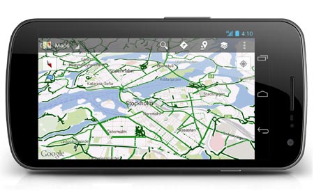
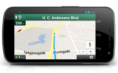
With the help of this software, users can take advantage of turn-by-turn directions by simply mounting their handset on the bike’s handlebar and switching over to the app. If it is tiresome to keep looking at the phone while riding, there is a speaker mode which orally dictates instructions. The map now covers roughly 5,30,000 kilometers and provides dark, light and dashed green highlights to indicate suitable routes for travelling.
“Whether you’re a seasoned century rider or a casual beach cruiser, finding the best biking routes can be a challenge. That’s why today we’re bringing mobile biking directions and navigation to the 10 countries where we launched desktop biking directions last month. Plus, we’re adding turn-by-turn, voice-guided biking navigation to Google Maps Navigation (beta) in every country with biking directions,” Larry Powelson, Software Engineer posted on the official Google blog.
The dark green lines point out dedicated bike trails, while the light green markings provide information on paths that have a separate bike lane. The dashed green highlight is for the streets meant for cycling. What’s more, users can also suggest and add new ways and directions to the existing ones offered by the application. As of now, this software is available for download in countries including Australia, Austria, Belgium, Denmark, Finland, the Netherlands, Norway, Sweden, Switzerland and the UK.
Google Maps for Android can be picked up via the Play store.