
Google Maps for Android version 6.10 has hit the Play store with enhanced features such as an improved Transit Lines layer and region highlighting. It also provides an updated layout of station pages providing departure timings, distance to the nearby stops and much more.
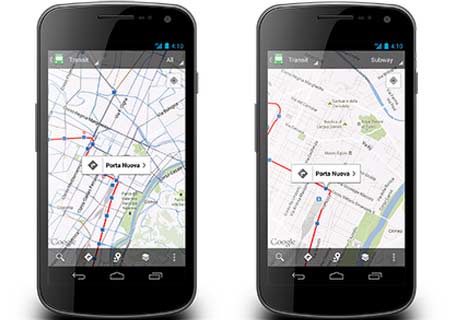
Through changes carried out to the Transit Lines layer, users will be able to pick out a specific mode of transport such as bus, train, tram or even subway. On selection, the remaining options will be hidden in order to make it easy for users to identify different routes and avoid cramping of information. This feature should prove useful for places that offer a host of travel options.
“Since 2005, we’ve collaborated with hundreds of transit authorities around the world to make a comprehensive resource for millions of riders to find out which bus, train, subway or tram can take them to their next destination. Today, Google Maps has public transportation schedules for more than one million transit stops worldwide, in nearly 500 cities including New York, London, Tokyo and Sydney,” exclaimed Christopher Van Der Westhuizen, Software Engineer, Google Maps, through the official Google blog.
Apart from the transit attributes, the update brings along improved region highlighting which marks out the border of a city or postal code searched. The My Places page setup comes with a number of new tabs to foster easy data access from a single interface, while the Location History feature enables users to go back to the places previously visited.
The Google Maps for Android version 6.10 update can be picked up via the Play store.